Headline photo

Headline photo
Rockcliffe and Kippford from South Glen Brae: Ed Iglehart [CC-BY-SA-2.0 (www.creativecommons.org/licenses/by-sa/2.0)], via Wikimedia Commons

Introductory text

Kippford and Rockcliffe are on the East Stewartry Coast, an unspoilt National Scenic Area with two other NSAs in close proximity. It is in Dumfries & Galloway, South West Scotland, a region known for it's wonderful scenery, biodiversity, turbulent history, smugglers and black and white 'belted' cattle known as Galloway Belties. This stretch of coastline has many names. Known locally as the Colvend Coast or the 'Secret Coast' (due to the peace and tranquility) it is often referred to as the 'Scottish Riviera' due to it being the holiday resort of choice for Victorian millionaires and having a Gulf Stream influenced microclimate: evidenced by palm trees in some gardens. Castle Douglas, the food town is a short drive away and Kirkcudbright, the Artists Town is over the next headland.


This a scenic and unique part of the world and we started the blog to share the experience of living in this wonderful place. We hope that it will be of interest to others who live here and give those planning to visit the area a taste of all it has to offer.


The blog has a correspondent in both Kippford and Rockcliffe village, you can also follow their Twitter feeds on the right of the page. If you would like to get involved we look forward to hearing from you.

Showing posts with label Walk Dumfries and Galloway. Show all posts

Wednesday, 10 October 2012

Rockcliffe to Kippford - Kippford to Rockcliffe Walk

The best ever family walk... (in our humble opinion) is the Rockcliffe to Kippford - Kippford to Rockcliffe Walk which takes in the famous Jubilee Path.

We have fond memories of doing this walk as youngsters with stop offs at shell beach and, what was then the Post Office and general store and now is, The Ark for ices creams! It is ideal for everyone with (on the whole) fairly level, man made paths or tarmac and not much in the way of hills. You can do it in either direction but we recommend starting from Rockcliffe as there is a good sized car park (and you can get an ice cream at The Ark half way round!).

Rockcliffe to Kippford Return - Jubilee Path
Time Allow 25 Minutes each way. Distance Approx 2.5 miles
Shoes Sturdy Comfortable the path is usually dry in Summer odd muddy patch during Winter. Path made up of grit/gravel and later tarmac.
A lovely walk with beautiful views out to sea and across the estuary on land managed and owned by the National Trust of Scotland. Lots of memorial seating on  the way where you can relax and enjoy the views. The Jubilee Path has been a favourite for many years and was named to commemorate Queen Victoria's Golden Jubilee

Pier at Rockcliffe overlooked by the Mote of Mark
Park at Rockcliffe car park Grid ref. NX847537 walk around the bay and take the path to the left of the public toilets. Pass through two kissing gates and in to meadow. Follow the path left and over a small wooden bridge. At gravel lane turn left you will see a gate on the bend on your left this takes you to the little pier with lovely views of Rough Island.


The path follows the shoreline at this point and passes two lovely, typically local granite Victorian cottages
Continue on gravel road through gate at cattle grid and straight on past the cottages with the Estuary on your left. After a slow incline you will see a cottage ahead of you,  take the right turn signed Kippford on a carved granite boulder. (see below)

Boulder Signpost for Kippford as modelled by Murphy
Follow this path, trying to suppress your curiosity and exploring all the little trails leading off from it. ( I always take a different path and always seem to end up in Kippford - although in different parts of the village. ) In our eight years of running the B&B and recommending this walk regularly we have not lost any guests on this walk day or night - yet!!

The path winds through National Trust for Scotland woodland 
After a few minutes the path splits, follow it to the left and down the hill. Its a little rocky here but the scenery at the bottom is beautiful. You descend to a T junction which is the private (no-through) road to Rough Firth (pedestrians and residents vehicles only )
In front of you there is a lovely shell beach and a bench a good place to rest a wee while. (the left turn is a dead-end but worth a peek as it takes you to the other end of the shell beach and the start of the causeway across to Rough Isle) 
Note: Dog owners please be aware that although very pretty, the shells can cut soft paws! 
Shell Beach Kippford looking South towards Hestan Island
At this point (signpost pictured above) take the road right and follow it in to the village. 

View looking up the Estuary from Rough Firth, North towards Palnackie  
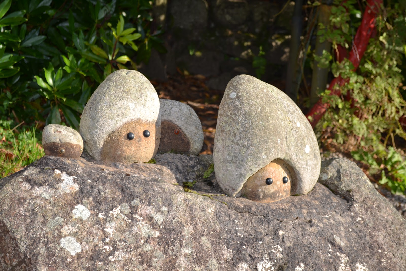
Funny Faces along the side of the road at Rough Firth


As you walk along the road you will see funny statues and amusing sculptures in a local artists garden on your right. A favourite with for children of all ages.


The yacht club pontoon and moorings, Kippford - Urr Estuary
When you reach  the newly renovated bus shelter and The Ark, you are at in Kippford, the halfway point of your walk. 
If you fancy a break or need sustenance for the return trip, you can stroll along the sea wall to The Anchor or The Mariner for lunch or pop into The Ark a lovely little coastal themed gift shop  which also does takeaway coffee, sandwiches, cake and ice cream.

From here take the road up the steep hill (this is the only steep bit, promise! Its a tarmac road, only a short hill and has good footing) and follow the Jubilee Path back to Rockcliffe past The Muckle and the Mote of Mark. This path has lovely glimpses of the Estuary, Hestan and Rough Island and several benches along the way. I love it as it changes with the seasons.

The National Trust for Scotland own and manage the area. Removing invading sycamore and creating habitats with the felled timber. Standing dead wood in the alder woodland creates opportunities for the great spotted woodpecker and the oak woodlands support more than 280 bugs and beasties along with jays and red squirrels who collect the acorns.


Photos taken with my Nikon D130 all photographs copyright: L Birdsall, Millbrae House
NTS copy taken from leaflet 'Mudflats to Meadows'

Thursday, 2 August 2012

Rockcliffe to Castlehill Point: A walk for spectacular views over the Solway


Rockcliffe to Castlehill Circular Walk 
2 miles allow 1hr to 1.15 hrs
Footwear: Sturdy/walking boots or wellies when it's been raining.


This is a pretty walk where you follow the coast so you have great views at all times. I did it at 7pm and the sun came out. The wild flowers were beautiful. The path was a little slippy underfoot, but it had been a wet day. Not my best photography as taken with a phone. I will get my new camera out next time.
Sign Post to Castle Point in Rockcliffe village


Park at Rockcliffe car park (free parking GR852535) and turn left down the road past the take away tea shop/ antiques. Just before the bay opens out in front of you turn left down the Merse - private road pedestrians only. You will see a sign post for Castle Hill 1 mile.


Rockcliffe and wild flowers
Near the end of the Merse (tarmac road), as the road turns  left and goes uphill, take the little path off to the right signposted Castle Point (see photo below).
Scottish National Trust Trail to Castle Point
As you walk along this stretch there are plenty of little paths off to the right to the shore and a few lovely benches to sit and admire the view over the Solway.

Hestan Island
Carry along this path and over wooden foot bridge (below). The path then splits take to path to the right so you are close to the shore.


At low tide you may see Mallard and  Wigeon. Along with various waders like Oystercatcher, Redshank and Curlew.

The path then opens out on a peeble beach but follow the curve around and head towards Port O' Beagle cottage and you will pick up the path again.


Back in to an area of hedgerow follow coastal path (you will see a few paths going up left ignore these thse bring you along the gravel lane to the camp site, the route we take back to the village)

Nelsons Grave


The story behind the grave of Joseph Nelson, which lies adjacent to the shore path (OS Map ref NX 852 528) is told in the History of Galloway dated 1841: -

'At the mouth of the Urr the headland of Castle Hill stands out boldly, bearing on its summit vestiges of an old Norse fortress. Here, in January 1791 a smuggling vessel from the Isle of Man went ashore and all hands were lost. Only one body, that of Joseph Nelson of Whitehaven, was cast up the following July. It was buried where it was found and where later his widow caused a stone to be erected'


Joseph Nelson was 69 years old and was buried on the shore rather than a cemetery as he was believed at the time to be a smuggler. Later his wife placed the gravestone in his memory.

Just after Nelsons Grave go through Kissing Gate and up small incline to the meadow.
Castle Hill Point


Where the path joins the meadow you can see Castle Point to your right. Head right towards it keeping to the edge of meadow to avoid damage to the grass or frightening any livestock that may be grazing. If there is livestock please keep any dogs under close control.

View South Eastward to Hestan Island


Castle Hill is the site of an ancient fort which was occupied in the iron age. You can see the mountains in the Lake District, St. Bees Head and the Isle  of Man on a clear day from here.
Grid Ref NX8552


View from Castlehill Point
The sure of foot may want to pass though the kissing gate and scramble down the path to the pebbled visible beach below. It's a bit of a pull back up but well worth it! 

To return back to Rockcliffe, retrace your path back to the edge of the meadow and at the point where you entered meadow carry along the edge of the field and through a gate. Please make sure all gates are closed. Follow the road past a few houses and through the caravan site. After a small slope at a small bridge where the gravel road turns to tarmac either turn left and you will be back at the wooden bridge along the path near the coast and follow the path back to village. Or carry straight on Barcloy Road until you join the road in to Rockcliffe and turn left down the hill back in to the village.
Around the meadow Rockcliffe in the distance
As always all images are copyright of the blog writers. Please do not use or reproduce them without permission. Thank you.