Headline photo

Headline photo
Rockcliffe and Kippford from South Glen Brae: Ed Iglehart [CC-BY-SA-2.0 (www.creativecommons.org/licenses/by-sa/2.0)], via Wikimedia Commons

Introductory text

Kippford and Rockcliffe are on the East Stewartry Coast, an unspoilt National Scenic Area with two other NSAs in close proximity. It is in Dumfries & Galloway, South West Scotland, a region known for it's wonderful scenery, biodiversity, turbulent history, smugglers and black and white 'belted' cattle known as Galloway Belties. This stretch of coastline has many names. Known locally as the Colvend Coast or the 'Secret Coast' (due to the peace and tranquility) it is often referred to as the 'Scottish Riviera' due to it being the holiday resort of choice for Victorian millionaires and having a Gulf Stream influenced microclimate: evidenced by palm trees in some gardens. Castle Douglas, the food town is a short drive away and Kirkcudbright, the Artists Town is over the next headland.


This a scenic and unique part of the world and we started the blog to share the experience of living in this wonderful place. We hope that it will be of interest to others who live here and give those planning to visit the area a taste of all it has to offer.


The blog has a correspondent in both Kippford and Rockcliffe village, you can also follow their Twitter feeds on the right of the page. If you would like to get involved we look forward to hearing from you.

Showing posts with label Walks. Show all posts

Saturday, 9 March 2013

A great walk for spectacular views: Mark Hill, Rockcliffe

Spring is here so it's time to dust of your walking boots and get out there.
We highly recommend this walk to guests at the start of their stay, especially if they are new to the Colvend Coast, as it gives you a really great view of the local area so you can orientate yourself.


Mark Hill Walk - Forestry Commission Scotland

Kippford and the Urr Estuary From Mark Hill

Time  - allow about 25 min's each way and time to take in the view.
Distance Approx 2 Miles
Shoes - sturdy, comfortable.
Difficulty - Moderate, A short walk on forestry paths but rough terrain and steep, rocky path up and down Mark Hill. Path made up of gravel road, wood chip, rocks, boulders. Muddy in Winter

Why do it - Amazing view


Rockcliffe and Castle Hill Point from Mark Hill

Start: From Rockcliffe car park turn left down the road (footpath) and walk down the hill towards the beach. Follow the road and go about threequarters of the way around the curve of the bay.

  Where a lane joins the road at a 90ยบ angle, turn right (signposted to Barons Craig Hotel) and then left at the T junction towards the Barons Craig Hotel (closed this year for maintenance ). 

Walk along the path flanked by stone walls until you come to a 5 bar gate and clearing in the woods.

Here you have four other path choices, you need to take the third exit. First left takes you to the Mote of Mark, second left (straight on) is the Jubilee Path to Kippford. Take the next path which is a gravelled forestry road (3rd Exit ) to the left of this road there is a Forestry Information Board with the Mark Hill Walk outlined on it. This walk detailed on the board is longer and two miles from this point. Great for the more energetic.
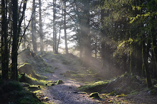
Forest Path opening out at Mark Hill
Walk up the Forestry Road about 4 min's (few hundred yards) and at the blue marker on the left turn left  again on a forestry road. As I write this there is a lot of work being done on these roads  but the work should be completed soon. Please adhere to all route closures and diversions for your own safety.

Blue Forestry Marker and Path to Mark Hill
Walk up this hill for about 10mins and you will see a small path leading in to the forest. Turn left at blue marker in to the Fir trees

A beautiful February Day
The path starts to get a bit rocky and a bit of a pull but you will soon be rewarded by the view.
West to Glen Isle
At the top of the hill follow the plateau to the left (South) and it will start to go downhill. This path is quite rocky so take care. Once at the bottom you join the Jubilee Path and can turn left back to Rockcliffe and the car park or right towards Kippford.

Jubilee Path towards Rockcliffe
 All photographs copyright - © L Birdsall, Millbrae House

Wednesday, 13 June 2012

Screel walk inspires local weaver Katie Russell


Katie Russell,  tapestry weaver and keen walker hails from Castle Douglas. Earlier in the year Katie did a walk with her Dad and, as it's one of my favourites as Screel tops the view out over the Urr Estuary from Kippford, we asked her to share her experience with us for the blog.  From Kippford and Rockcliffe, the Screel walk is a short drive away along the A710 to Dalbeattie, left to Palnackie along the A711 (the road along the opposite shore). We are excited as it's our first long walk on the blog and it is especially interesting as Katie uses what she sees whilst out and about as inspiration for her work. For Katie her work, as with the walk, is a journey and so the two are symbiotic. 

Screel Walk courtesy of Katie Russell

NOTE: To get to the Forestry Commission car park at the foot of Screel follow the A711 from Dalbeattie or Kirkcudbright. (The car park is signposted south of Palnackie) 

It was easy to find the way and we arrived early, before 9am so the car park was empty. This was on a Sunday. Dad wasn't sure if we would get the walk done in the estimated time. He started in his shoes, but went back to the car to get his boots!  

The start of the walk is a gentle slope through the forest and that is easy going. 
When you come out of the forest there is a track that goes off to the left and another steep
path right beside it. Take the steep path. If you go on the first left you will end up in another forest!

Looking seaward: Kippford and Rockcliffe are top left of the photo: copyright K Russell


We realised that there were alternative paths, it depends on how adventurous you are feeling! Keep climbing the hill until you get to a bench from where you can admire the view of the bay.  We stopped there and had some water. 

You can then go straight into the forest and follow the path that is worn away, so you shouldn't get lost. Watch for tree roots if it has been raining, it is easy to stumble over them.  As you come out of the forest you will then start to see heather on the way up the hill. There will be areas that are boggy......unavoidable I'm afraid! But if you are wearing a good pair of walking boots then there should not be a problem. 

View from the summit of Screel: copyright K Russell
You keep going up until you are at the top from where you will see a fantastic view of the bay and also be able to see the cairn on the other summit on Screel. Walk over to there and then you will see more inland views over to Palnackie and Castle Douglas. 
It is advisable to take an OS map with you if you really want to be sure to identify the
places you see. My father enjoyed looking at how much of the coast line comprises of sand flats. Bengairn is the neighbouring, slightly higher hill, that is impressive and would also give great views. We contemplated it, but decided to keep that for another day.  Bengairn like Screel has heather and bracken, but will provide spectacular views also.

There are a number of paths going around Screel and it depends on how long you want to take to get to the top. If you want a short walk, then retrace your steps back the way you came. Alternatively you can follow a track down the side of Screel where the cairn is. Be advised there are rocky parts and walking poles come in useful in places! Dad managed with one, but I needed two. We found that going slowly, stopping every so often to take photos, stopping at the top and going slowly down took us back to the car park in about 3.5hrs. 


Twin Peaks: the summit of Screel: copyright K Russell
The heather and bracken was lovely in contrast to the greens of the forests.  I took a lot of photos of this and eventually worked up a sampler in wool, cotton and silk inspired by one of the images.

We startled a couple of deer that shot out onto the path in front of us.....too quick to take a photo unfortunately!
A grass snake, lots of interesting beetles and we heard a red grouse. The rock formations are interesting going up Screel and on the way down. My father took images of the rock formations and was quite interested in possibly producing watercolours from them. We came across a few people of all ages on the walk, all kitted out in outdoor gear with poles.


The stone cairn on the summit of Screel: copyright K Russell
The top of Screel is not somewhere to sit for too long if you are not wrapped up, but is excellent for photography and for the hardy, some painting and sketching.  I found the views of Bengairn and Tum Hill quiet inspiring with all the contrasting colours and textures. I will definitely come back and see the heather when it has changed in colour to give me more ideas. I would like to explore using thicker wools and possibly other coarse yarns. Although it was slightly misty in the distance this provided some inspiring images too. There were a lot of images really that could be used for all kinds of artwork. That is what I love about walking in this region. There is variety. 


This walk is particularly worth doing if you want to see the views of this region and into England. 

A photo of the weaving sampler that Katie wove inspired by the walk. Katie says "It took 

many hours of blending colours, but was worth it. Couldn't have produced that without

being inspired by the landscape." 

It was inspired by the heather, bracken, forest and sky and woven with wool, cotton and silkcopyright K Russell


 I was doing the walk as a novice! I am not an experienced hill walker at all! But it was well worth the steep climb! At present I am gathering images together from different parts of the region for one of my projects and Screel was a good starting off point.


You can find more information on Katie and her work on the kfrweaving website


Thank you Katie for sharing this with us.

Saturday, 14 April 2012

It's blooming well Spring!

After a stressful day of thrashing around Tescos and crashing away at my poor computer I felt I deserved a treat so around 17.30 donned my walking boots, scooped up Murphy the Wonder Dog and parked up at Colvend Village Hall car park.


The air was balmy, the sky blue and the sun dipping towards the West. With a wag of an enthusiastic Collie tail we set off along the track to the Eastern end of Dalbeattie Forest that runs alongside White Loch and on to Clonyard Loch. 


Not a Crossbill in sight which was unusual but the Green Woodpeckers were making thier presence known with their distinctive Yaffle (call). There seem to be a good number about this year, I've heard them in Kippford, Sandyhills and Colvend this week. Far more around than usual - a very good sign!


As it was late we kept it short and looped around Smithland Hill and back to the car park.


The whole walk was a joy, due to the display of Spring flowers we spotted along the way... hope you enjoy them too.


Ended with Blossom back at Colvend Village Hall


Sunday, 1 April 2012

These are a few of our favourite things.........

As it's the Easter Holidays I thought it would be a lovely idea to hand over our seasonal blog post to a post done by children. So, for all  families and those young at heart visiting the area here is Dumfries & Galloway through younger eyes. Enjoy!


Sunday, 18 March 2012

Strange goings on?

On returning to the car park after my morning constitution at 9.30 on Saturday 17th (well it was such a lovely day I could hardly stay indoors, could I?) I spotted two very unusual, and hopefully rare, birds on the RSPB Mersehead Reserve. The strangest plumage you have ever seen and not of the usual size. Were they some migrants blown in by seasonal storms or just two weary birds on passage?


Before the Twitchers amongst grab your identification books and plan a trip to Mersehead, I think you better see them for yourselves. Luckily, although they were shy little creatures I did manage to get a photo of each of them.


Apparently this is a Barnacle Goose...
and this is a Puffin.


It turns out that these brave souls were helping out at a sponsored walk on the reserve so deserve a round of applause.


Over 60 walkers were raising money and set off on a blissfully sunny morning at about 10.30. The walk went to parts of the reserve not normally open to the public and was organised to help raise vital funds for the continuing conservation work at Mersehead.


Looks like they had a lot of fun!

Saturday, 3 March 2012

Help with the New year's Resolution...


Saturday morning, and a good time to get out for a walk, I can't quite believe it's a week since the annual community walk designed to kick off Health Week.

I had made a New Years Resolution to get out and walk more and a quick glance at my Winter muffin tops confirmed I needed it so I joined around 56 folk at Colvend Village Hall for the off and I was glad I did.  We had a great walk, designed to suit all ages and well within my winter hibernation mode capabilities.

The walk, organised by our very proactive village Primary it was attended by pupils past and present, parents friends, community members, staff and an array of dogs of all shapes and sizes. It was a great opportunity to catch up with friends and have a natter. Walkers ages ranged from about 3 years to ..... well, dare I say without fear of being lynched at the next community event, let’s leave it as.... the more mature. There was much interest and curiosity as, for the first time on the walk each of us were issued with a pedometer. 

The weather was not quite as sunny as forecast, but did not disappoint as it stayed dry and crisp, as an army of us set forth at 10 am for an hour and a half walk. Not 'hat and gloves' weather but my thermals (although over hot at times) were appreciated on the top of the hill, where a cool breeze blew away the cobwebs.

From the Village Hall the walk took us around the NE shore of White Loch and at Barean Loch turned right past Smithland Bothy and up Barcloy Hill. The views of the stunning Solway coastline were our reward for the final push. Living here and usually seeing the views from just above ground level – not that I am that vertically challenged, it’s great to get up high and get a real feel of the whole area. Colvend Church (built on the site of a medieval building during the Rev. James Chalmers' ministry and opened in 1911) sits 
beautifully in the rolling Galloway countryside and further away Rockcliffe nestles around the crescent of beach. You can see our approximate route here:

Route courtesy of Google Earth™ mapping service

Participants arrived back  at the Village Hall, some muddier than others, at around 12- 12.30 to a wonderfully tasty, healthy, lunch. There was a selection of homemade soups with rolls (I went for the celery – delicious),  home made salads of cous cous, coleslaw and potato followed by (perhaps not quite as healthy but very yummy) flapjacks with tea or coffee. 

Pedometers read varying distances from 4.5km to 7km depending on how many times they had been shaken up and down by, might I suggest, the more mischievous amongst us, well you are not telling me all those little legs walked that distance in that time!

The event raised a sum of £125 for the school and a big thank you to all that organised it, prepared lunch and, the worst job of all, washed up!

Well the sun has just peeped out so it's time to don my walking boots and head on out!

Sunday, 19 February 2012

A chilled Chablis of a day...

It was such a beautiful day we just could not resist getting up and getting out. Visibility was superb, the sun bright, the sky a cerulean blue and the air intoxicating. It was a morning as crisp, clear and bursting with flavour as a glass of chilled Chablis - every sight, sound and scent, fresh, vivid and clear. Paradoxically, it was what I think of as the perfect Autumn day.


8.30am saw us at the RSPB Mersehead Reserve at Southwick. The Visitor Centre (a converted traditional, whitewashed Galloway cottage) looked pretty as a postcard in the morning sun.
We decided to head East for a change as the sun was still so high. (Later in the day it's better to set off West) Despite the sun, last nights' frost spangled the grass and made artwork of the puddles as we strode out along the lane towards the Sulwath centre and the two hides. (It was a day made for striding - Brisk and invigorating).
Recent hedge trimming had revealed the remains of a last years Long Tailed Tit nest along the lane, there is a healthy population of them around here and I love it when around 12 - 15 all try to get on the same fatball. It always makes me laugh as it looks like some outlandish Xmas tree decoration.


We decided to visit Meida hide as you can usually spot Deer to the East of the wetland area in front of it so set off through the woodland. Unfortunately we didn't see the Treecreper who is usually about (maybe he was having a lie in?)


From the point when we left the car we had Barnacle Geese flying sporadically overhead. Their distinctive calls, described by some as like a dog barking, punctuating the whole 2 hour walk. Large numbers of the Svalbard population arrive at Mersehead in the Autumn and can be seen grazing the wet areas in densely packed flocks throughout the Winter months. I am always sad to see them go. There are 9,000 Barnacle Geese this year, a lower number than last year but still a fantastic spectacle. Not to be missed.   
After 20 mins in Meida Hide where we spotted all the usual suspects (waterfowl) we then went out onto the beach, Murphy's favourite place. Being a stick hound he loves the wide open space where he can chase sticks to his hearts content. The view was amazing. The East Stewartry Coast from Southwick along to Castle Point at Rockcliffe at the end of the long sandy beach. The dunes are very special and protected along with the rest of this coastline which is designated as a SSSI and a National Scenic Area.
Our bird list this morning included Barnacle Geese, Curlews, Phesant, Pink Footed geese, Chaffinch, Green Finches, Yellow Hammer, Snipe, Mallard, Widgeon, Teal, Pintail, Coot, Gadwall, Mute Swans, Lapwing, Skylarks to name a few.  It was a fantastic walk, one I will not forget. You can see the route here:
You can do the circuit in about an hour but today we lingered and savored the day. At the Visitor Centre you can get Fairtrade coffee and tea and Chocolate Muffins and Brownies to go with it or even a tub of delicious Cream O' Galloway ice cream. There are a couple of big squadgy sofas where you can sit in the sunshine and watch the birds on the feeders or borrow Binis' to look out over the Lapwing nesting area. The team of permanent and volunteer staff on the reserve are always on hand and are a great bunch of people. They do a fantastic job so a big thank you to them for all their hard work.

Wednesday, 15 February 2012

First sign of Spring?

Walking along Sandyhills beach at dusk we heard our first Song Thrush. Not in full voice, just warming up, but glorious none the less. Is this our first real sign of Spring? The snowdrops around the lodge have been eagerly pushing up for a while now so must be due to bloom soon so maybe it is. 


Later, as the sun had just set and a candy pink line traced the horizon while everywhere else was coloured hues of purple, graphite and black so we could hardly see the dog swimming in the stream below, we saw our first 'Norah' (Batty) of the year flitting around the bridge that spans Barnhourie Burn where it meets Sandyhills Bay. It seems that Spring has officially arrived along the Colvend Coast.

Sunday, 12 February 2012

A mizzy day in Dalbeattie forest

Perhaps on the face of it not the most auspicious day for the first real post with mizzy weather and a chill in the air but we were to be proved wrong. Wrapped up well with hats, scarves and gloves  we set off from Richorn Trail Head, just outside Dalbeattie (the Dalbeattie 7 Stanes start point and carpark - just 4 miles from the lodge). 


The air was sharp and fresh and sounds in the forest had a muffled quality due to the low lying cloud but gave the trees a secretive air. It proved to be an eventful hour and a half.


Several groups of mountain bikers in coloured lycra and waterproofs passed us en route, Murphy (the wonder dog) said an enthusiastic hello to several chums (including a blind Labrador - I kid you not - but that's a story for another day) and two very cheery walkers greeted us going in the opposite direction. Dalbeattie Forest is a great place to get to know people, especially if you have a dog with you!


At Plantain Loch we stood awhile and watched the Heron showing early signs of getting flirty. It's harsh calls cut through the sea fret and sounded almost tropical. The mist, the half frozen lake, the dark fir trees and the Heron made a striking image - almost in monochrome.


A lone Canada goose passed overhead at one point, flying NE, it's unusual to see a single goose which made it remarkable.


The woods were very atmospheric and alive with people, dogs and wildlife which just shows what a good walk can be had, even on a mizzy day.  It is noticeable that there are suddenly more people around for the first time this year - probably due to the school half term.


Before heading home for a well deserved Hot Chocolate we had a peek at the site work going on at the cottage at the edge of the forest by the main entrance - they have just got planning permission to open a cafe and tea room so we are watching the progress eagerly. A good tearoom/cafe close by will make a perfect end to a good walk in the forest... watch this space!