Headline photo

Headline photo
Rockcliffe and Kippford from South Glen Brae: Ed Iglehart [CC-BY-SA-2.0 (www.creativecommons.org/licenses/by-sa/2.0)], via Wikimedia Commons

Introductory text

Kippford and Rockcliffe are on the East Stewartry Coast, an unspoilt National Scenic Area with two other NSAs in close proximity. It is in Dumfries & Galloway, South West Scotland, a region known for it's wonderful scenery, biodiversity, turbulent history, smugglers and black and white 'belted' cattle known as Galloway Belties. This stretch of coastline has many names. Known locally as the Colvend Coast or the 'Secret Coast' (due to the peace and tranquility) it is often referred to as the 'Scottish Riviera' due to it being the holiday resort of choice for Victorian millionaires and having a Gulf Stream influenced microclimate: evidenced by palm trees in some gardens. Castle Douglas, the food town is a short drive away and Kirkcudbright, the Artists Town is over the next headland.


This a scenic and unique part of the world and we started the blog to share the experience of living in this wonderful place. We hope that it will be of interest to others who live here and give those planning to visit the area a taste of all it has to offer.


The blog has a correspondent in both Kippford and Rockcliffe village, you can also follow their Twitter feeds on the right of the page. If you would like to get involved we look forward to hearing from you.

Showing posts with label Walks around Kippford. Show all posts

Saturday, 9 March 2013

A great walk for spectacular views: Mark Hill, Rockcliffe

Spring is here so it's time to dust of your walking boots and get out there.
We highly recommend this walk to guests at the start of their stay, especially if they are new to the Colvend Coast, as it gives you a really great view of the local area so you can orientate yourself.


Mark Hill Walk - Forestry Commission Scotland

Kippford and the Urr Estuary From Mark Hill

Time  - allow about 25 min's each way and time to take in the view.
Distance Approx 2 Miles
Shoes - sturdy, comfortable.
Difficulty - Moderate, A short walk on forestry paths but rough terrain and steep, rocky path up and down Mark Hill. Path made up of gravel road, wood chip, rocks, boulders. Muddy in Winter

Why do it - Amazing view


Rockcliffe and Castle Hill Point from Mark Hill

Start: From Rockcliffe car park turn left down the road (footpath) and walk down the hill towards the beach. Follow the road and go about threequarters of the way around the curve of the bay.

  Where a lane joins the road at a 90ยบ angle, turn right (signposted to Barons Craig Hotel) and then left at the T junction towards the Barons Craig Hotel (closed this year for maintenance ). 

Walk along the path flanked by stone walls until you come to a 5 bar gate and clearing in the woods.

Here you have four other path choices, you need to take the third exit. First left takes you to the Mote of Mark, second left (straight on) is the Jubilee Path to Kippford. Take the next path which is a gravelled forestry road (3rd Exit ) to the left of this road there is a Forestry Information Board with the Mark Hill Walk outlined on it. This walk detailed on the board is longer and two miles from this point. Great for the more energetic.
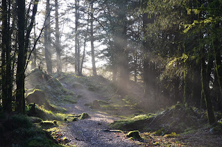
Forest Path opening out at Mark Hill
Walk up the Forestry Road about 4 min's (few hundred yards) and at the blue marker on the left turn left  again on a forestry road. As I write this there is a lot of work being done on these roads  but the work should be completed soon. Please adhere to all route closures and diversions for your own safety.

Blue Forestry Marker and Path to Mark Hill
Walk up this hill for about 10mins and you will see a small path leading in to the forest. Turn left at blue marker in to the Fir trees

A beautiful February Day
The path starts to get a bit rocky and a bit of a pull but you will soon be rewarded by the view.
West to Glen Isle
At the top of the hill follow the plateau to the left (South) and it will start to go downhill. This path is quite rocky so take care. Once at the bottom you join the Jubilee Path and can turn left back to Rockcliffe and the car park or right towards Kippford.

Jubilee Path towards Rockcliffe
 All photographs copyright - © L Birdsall, Millbrae House

Saturday, 16 February 2013

Enjoy Dumfries & Galloway with some of the best access rights in the world

As outdoor enthusiasts we are very lucky, here in Dumfries & Galloway, to enjoy some of the best access rights in the world. 

Which is fantastic for the many people who come here to enjoy the amazing biodiversity and recreational facilities Dumfries & Galloway has to offer. The Land Reform (Scotland) Act 2003 gives the public the right to be on most land and inland water for recreation, education and going from place to place, providing they act responsibly. 

The "Scottish Outdoor Access Code" (as it's known) provides guidance on access rights and responsibilities but  it is not in it'self an authoritative statement of the law, although it has been approved by Ministers and the Scottish Parliament. As I understand it, the code is more of guidelines that, if followed, help you observe the law and are an example of good practice when out-and-about in the countryside.

Many of our guests are keen walkers, birders, cyclists or dog owners and most come from outwith Scotland. As Scottish access rights are different to other countries they are often  hesitant when going out and about, as I was when I first came here. I grew up in Yorkshire where the only option to explore the countyside was to use a permissive footpath so although I love the freedom,  I am still sometimes uncomfortable 'roaming free'. With this in mind I looked up the  Scottish Outdoor Access Code when I moved here and always check my rights over my chosen route before I go.

Guests often ask about the Scottish right to roam when exploring our beautiful countryside so I thought it would be a good idea to do a post about the "Scottish Outdoor Access Code" as a handy reference. This is just intended as a quick overview, there are links to official publications at the bottom.

The Land Reform  (Scotland) Act 2003 gives you the right to enjoy:

• Informal pastimes such as walking, camping, picnicking and sightseeing
• Active pursuits including cycling, mountaineering, canoeing and horse riding
• Dog walking, provided your dog is under proper control
• Taking part in recreational and educational trips
• Simply going from one place to another

NOTE: Motorised activities (unless for disabled access) and hunting, shooting and fishing are NOT included.

... over most of Scotland including:
• Urban parks
• Hills and woods
• Most grass fields and field margins
• Beaches
• Lochs, rivers and canals

However, in the interests of safety and to encourage goodwill between the public and to land owners and managers, it is equally important to note the places where you CAN NOT exercise this right. 

The main places where access rights do not apply are:

• houses and gardens, and non-residential buildings and associated land
• land in which crops are growing
• land next to a school and used by the school
• sports or playing fields when these are in use and where the exercise of access rights would interfere with such use
• land developed and in use for recreation and where the exercise of access rights would interfere with such use 
• golf courses (but you can cross a golf course provided you don’t interfere with any games of golf)
• places like airfields, railways, telecommunication sites, military bases and installations, working quarries and construction sites
• visitor attractions or other places which charge for entry


The Code: is based on three key principles which apply equally to both parties, the public and land owners or managers. These are simply, in my opinion, basic common sense and are second nature to most countryside lovers/users and wildlife enthusiasts so are not onerous to abide by.

1. Respect the interests of other people. 
Which means acting with courtesy, consideration and awareness. If you are exercising access rights, make sure that you respect the privacy, safety and livelihoods of those living or working in the outdoors, and the needs of other people enjoying the outdoors. If you are a land manager, respect people’s use of the outdoors and their need for a safe and enjoyable visit. 

2. Care for the environment. 
If you are exercising access rights, look after the places you visit and enjoy, and leave the land as you find it. If you are a land manager, help maintain the natural and cultural features which make the outdoors attractive to visit and enjoy.

3. Take responsibility for your own actions. 
If you are exercising access rights, remember that the outdoors cannot be made risk-free and act with care at all times for your own safety and that of others. If you are a land manager, act with care at all times for people’s safety.

There are also places where, although not specifically excluded,  you are expected to exercise basic common sense; these include bird nesting sites such as wetlands and shingle beaches which should be given a wide berth during the breeding season in late Spring. An example of this locally is Rough Island (an island bird sanctuary just off Rockcliffe/Roughfirth with nesting oystercatchers and ringed plovers. There are signs asking people not to visit during the breeding season in May and June.

I hope that this post is useful as knowing the code gives me the confidence to explore freely. 

You can get more extensive guidance and download several documents here:

These include:


I hope this helps you to enjoy the wonderful diversity Dumfries & Galloway has to offer to the full, particularly in this Year of Natural Scotland

Source: Scottish Natural Heritage - http://www.outdooraccess-scotland.com/


Saturday, 21 July 2012

Short Rockcliffe Walk to Mote of Mark

Mote of Mark Circular - Rockliffe Short Walk 

(Allow 30 to 40 Minutes - with ice cream stop)


Start at Rockcliffe car park
Road winding down to bay - Rockcliffe
From the car-park (free parking) turn left and walk downhill towards the beach and around the pretty bay to a small area of 20min parking and public toilets. Turn right up a small path to left of toilets to first metal kissing gate after gate turn left and then right through another kissing gate in to Rockcliffe Meadow.
National Trust Scotland Rockcliffe
When path opens out at corner of meadow take worn path straight ( as gravel path turns left) on so you are crossing meadow and head towards wooden footbridge across burn.
The meadows are managed by the SNT and support a rich diversity of grasses and wildflowers. These support many mammals, birds and invertebrates.


Cross bridge and follow path round to right to information board about the history of the Mote of Mark. The Mote of Mark is now in front of you.Continue up meadow to wooden gate.
Mote of Mark

The Mote of Mark was once a defended hilltop overlooking the Urr estuary. It was the court or citadel of a powerful Dark Age chieftain, possibly one of the princes of Rheged. Archaelogical excavations show the site was occupied during the 5th and 6th century and appears to have been destroyed by fire in the 7th century it is thought by the Northumbrian Angles.


Woodpecker Trail Rockcliffe


NTS Dark Age Fort
 Through gate and after a few feet the path splits  take the path to the left up to the top of the Mote. A bit of a climb with steps but well worth the view.

View from Mote of Mark looking SE towards Castle Point


Rough Island closest to the shore is a 8ha bird sanctuary which is accessible at low tide by foot via a causeway.  ( always refer to a local tide table before walking to the island ) The island is a bird sanctuary with nesting oystercatchers and ringed plovers and access is restricted during May and June to avoid disturbance.


Rough Island and Causeway
 Retrace your steps back down the hill and at bottom where path meets up with Woodpecker Trail turn left for a short while and then right through first wooden gate.
Woodpecker Trail Rockcliffe
 Follow Trail past Hawthorn Trees and through another wooden gate past carved Woodpecker to a point where five paths meet.

Carved Woodpecker on trail

Turn right down lane past the Barons Craig Hotel and at entrance to hotel turn right through gate next to cattle grid and back across meadow towards the two kissing gates and back to beach.

Path past Barons Craig Hotel


Low Tide - Hestan Island from Rockcliffe Bay


Ice Cream Stop


Coffee and cakes at the take away Garden Tea Room Rockcliffe
Gar.den Tea room is  close to car park andopen most days during the school holidays and sells a selection of antiques and paintings. Tea, coffee and cakes to take away or enjoy in the garden
All images copyright L Birdsall.